Every company currently involved in developing, validating and applying products for the agrofood chain must choose from a wide range of imaging technologies which claim to improve performance of development or operational capabilities. The key questions these companies must ask is how they can get the most out of these technologies, and even more importantly, how can they integrate these technologies into current workflows in a simple and logical way.
At VITO Remote Sensing we have been active for over 25 years in using satellite, aerial and drone imagery in an agricultural context. Our mission has been clear from the beginning: use remote sensing technology to accelerate towards a more sustainable world. We specialize in extracting plant trait information from a wide variety of platforms & sensors, and delivering results with clear APIs towards customers and partners.
Drone based phenotyping
With MAPEO we offer one of the best performing solutions for drone based phenotyping currently available. This because at VITO Remote Sensing we combine our sound scientific knowledge on image analytics with a state-of-the-art software solution which can provide plant trait information directly to the operational pipelines of our customers and partners. Think about things like fruit counts, disease detection, height measurements, growth monitoring, plant emergence, and any other trait a breeder would be interested in.
From this year onwards we are offering our software solution as a stand-alone service, where you can take complete control of your workflow from data acquisition through to analysis and extraction of your traits. Using this, you can expand the use of drone based phenotyping within your own organization or offer our solution towards your customers.
We also offer the possibility for you to take advantage of our object detection and segmentation AI workflows, optimized for phenotyping use cases , to create models which allow you to identify the precise location of traits across your trial fields. These workflows allow for a light weight set up of a feasibility study to explore the detection of innovative traits for your crops.
See the bigger picture
But we don’t stop at the borders of the experimental field and neither should you! How are your newly selected varieties doing later, during seed multiplication for example? What are the environmental conditions under which the official country trials are organized? How does my product perform on farmer’s fields compared to other varieties?
At VITO Remote Sensing we have a strong background working on global satellite based agricultural services which we are opening up for our phenotyping customers. With flagship platforms like WatchITgrow and Terrascope we generate useful information at field scale and allow you to analyze any field of interest, even back in time.
This way you can follow your seeds or products outside of your organization, which opens up a whole new world of possibilities.
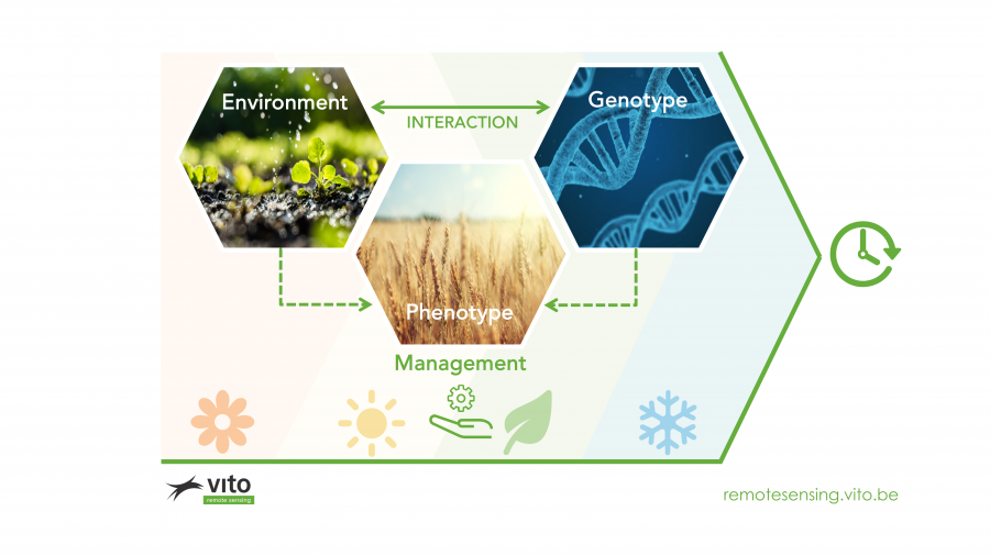
Adding insights gained on how your varieties perform on farmer fields, all with their own specific management practices will bring a new feedback loop to your breeding process. GxE suddenly becomes GxExM! By getting in touch with farmers through online platforms, it will also be possible to interact directly with farmers. Think about improving cooperation with farmers in seed production or even changing your business models. It opens up the possibility to move away from simply selling a seed, to selling a seed with advice, matching crop protection products, a micro insurance etc etc.
How can this be realized?
- The genomics domain is already well explored and gives all the insights needed through companies like Keygene and the R&D units/expert in leading seed businesses
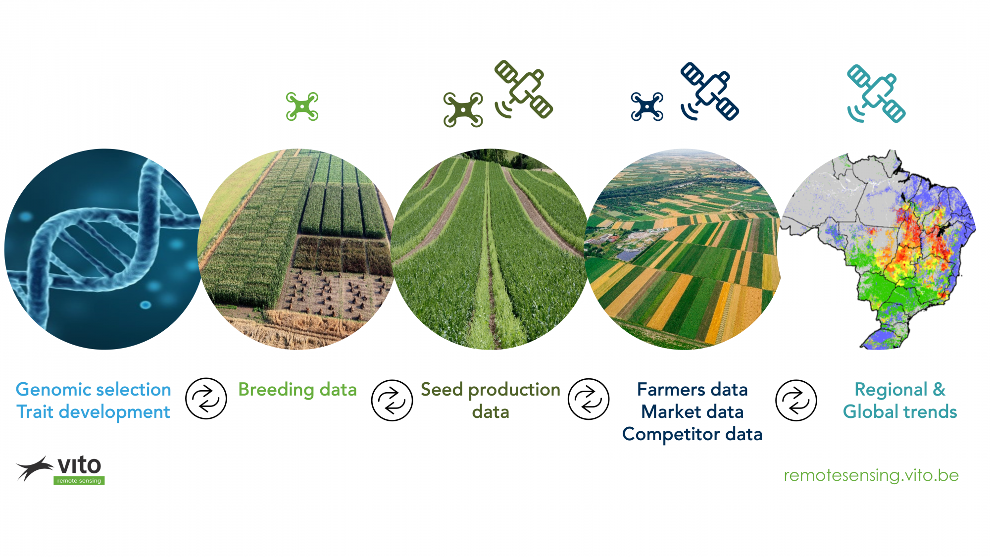
- Linking objective large scale digital trait data from field trails through drone based phenotyping will allow you to gain better insights much faster. Creating better seeds.
- By upscaling insights gained through drone technology to space technology, you'll get the same trait information as from the experimental fields, but now on a large scale for farmer fields. Connecting with these farmers and understanding the broader environment and management practices through digital platforms opens up the potential to use this data to improve the breeding process and, allows seed breeding companies to interact with the very same farmers.
- Leaves us with the time dimension. Off course all data collected has 'time' link, understanding the impact of the seasons, climate (change) and time to assess for example evolution of draught stress or spreading of certain pest and diseases throughout a region or continent will allow to better target sales and marketing efforts and at the same time steer development strategies to align with these evolutions.
The need for scalable and integrated solutions
To implement the technologies to realize these goals you'll need (as an organization) technology that can scale . Monitoring trial fields by drones will require a certain level of standardization both in terms of data acquisition and in data processing. Being able to compare data collected on fields in many different regions is essential.
A clear vision on how to manage and integrate this data into the day to day processes will be equally important.
The challenges involved in developing and implementing digital phenotyping practices in the seed business are well known. Shifting from the current culture to a management approach where data-based decision making is embedded in key processes and activities is not easy. Often, companies lack data analytics, drone or remote sensing platforms and experts. Or they work in cross functional teams where silos have been the norm and they struggle to align decision making processes and meet accelerated timelines, across breeding, marketing and production. What most business leaders underestimate is that digital transformation is not just about technology: Above all, it is about leadership and people. That makes it complex – thus requiring a new approach for managing the change.
Based on our experience, we therefore offer our partners an integrated approach, working closely with different stakeholders in their organizations, where we take into account tangible elements such as technology, hardware, software, processes and reporting structures but also intangible elements such as culture and teams throughout the transformation journey and across the entire company.
At VITO Remote Sensing we can help you with both aspects.
We invested heavily in a fully automated scalable drone imagery processing and analytics infrastructure (MAPEO) that runs in the cloud. Accessible from about anywhere in the world and easy to upscale in terms of processing capabilities. Besides this we can guide you in the operational implementation process and change management needed to integrate this technology in your organization.
On top of that, you want to translate and upscale the insights gained at experimental fields to large scale farmer fields by making use of satellite based sensing technology and have the necessary tooling to interact with farmers. Also there, VITO Remote Sensing has invested in the infrastructure to support companies in this journey. Whether you prefer to use the back end infrastructure to develop your own front end application or you want to use our WatchITgrow application. We have the expertise, technology and know-how to support you.
We look forward to supporting you.
Contact us to learn how we can help you in this exciting digital journey.
Jurgen Decloedt
Jurgen.decloedt@vito.be
https://remotesensing.vito.be/
VITO_RS_ (Twitter)