The agriculture industry is facing significant challenges due to regulatory constraints on the use of plant protection and fertilizers, as well as the growing effects of climate change. These challenges have led to an expansion of plant pathogens and extreme weather conditions, which negatively impact crop yields.
However, assessing the impact of climate change and the adaptive response crops will need based on likely or expected future weather scenarios is difficult.
Developing climate-adaptive crops is crucial, integrating multiple disciplines and technologies such as genotyping, phenotyping, and envirotyping in combination with robust climate models can contribute to the development and delivery of climate-adapted crops in a shorter timeframe.
Large scale remote sensing-based phenotyping at the tipping point
Over the past years, breeders have been gradually able to obtain more phenotypic and environmental data at lower cost which has opened enormous opportunities in the multi trait and multi environment prediction domain.
Thanks to Moore’s law, it is now possible to collect a wealth of data on experimental trails across many different environments at the cost that is now a fraction of what it was 10 years ago. High quality drones have become affordable and easy to use. Where drones were expensive tools that required special training and licenses to operate in the past, they have become an essential tool in the toolbox of the breeder.
Through the big space investments by the EU through the Copernicus program and the growing competition in low orbit space, high quality and high-resolution satellite imagery has become accessible, useable and affordable, offering a complementary and scalable data source for breeders. It is now even possible to get phenotypical data from operational fields at scale to monitor the performance of varieties in a wide range of conditions. Also, phenotyping local field trials with high resolution satellite imagery becomes more and more possible.
Making the agricultural system resilient against climate change
Climate change is expected to increase weather variability and enlarge the vulnerability of already susceptible regions, including but not only, those that are already warm and prone to drought.
Low water availability is for example one of the main driving forces that put crop yields under pressure across the world. With climate change, the frequency and intensity of heat waves and drought will increase in many areas around the globe. Therefore, drought tolerance has become a major breeding target for many (row) crops. Adaptation is essential to make existing agricultural systems resilient against climatic changes and extreme weather events and to maximize agricultural yield.
Having access to reliable region-specific climate models will not only be important to better steer breeding programs, it also allows on short term to optimize the day to day efficiency of field trials.
How to bring all of this together?
As an independent research organization, VITO offers scalable and affordable technology solutions to help seed breeding companies and input suppliers to get more and better data on the table and help them in the race against the clock to breed new resilient crop varieties.
Large scale drone and satellite phenotyping
When deploying large scale drone phenotyping across multiple environments and regions, some challenges arise. The main challenge being data consistency as you want to be able to compare data across various regions for all genotypes.
The focus should be on both standardizing data collection, flight execution and obviously data processing and analytics. With MAPEO, VITO offers the tools, operational procedures and the know-how to ensure this data consistency at all levels. We stand by our customers and advise them on appropriate hardware, have defined a set of procedures for data collection and even provide tooling to drone pilots to validate data quality immediately after the drone flights have been executed. All of this ensures good quality input data that is fed into our automated image analytics workflow so that our users get high quality, reliable and consistent statistics on their plant traits.
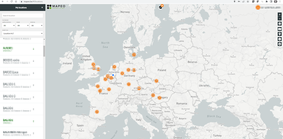
Where the application of drone data has limits in term of scalability (it still requires a pilot to fly the drone), satellite-based solutions offer great benefits in scalability. One satellite image captures several km2 in one shot; and satellites often have (multi)daily overpasses and require little to no manual intervention. Satellite data can offer much more added value than only providing trait information of your field trials.
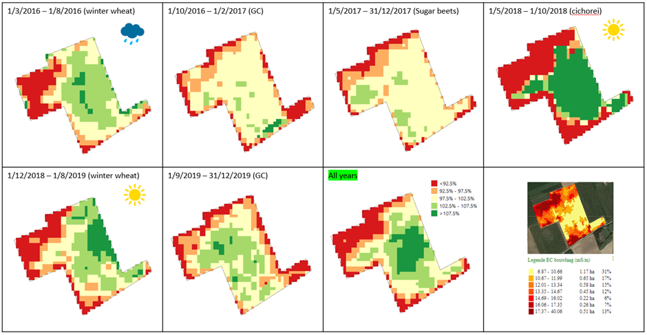
Even the ‘public’ satellites with a coarser resolution bring valuable information. Long before you started your experiment on a particular field, satellite imagery has captured the soil heterogeneity over many growing seasons. While you might have been spending money on expensive repetitive plot designs to capture the environmental heterogeneity of your experiment, the information was already available from historical satellite imagery. Through MAPEO we offer these satellite-based solutions to our users, unlocking the possibility to identify the best possible fields for future trials in unknown regions.
Try yourself for free through this link
Predictive climate models
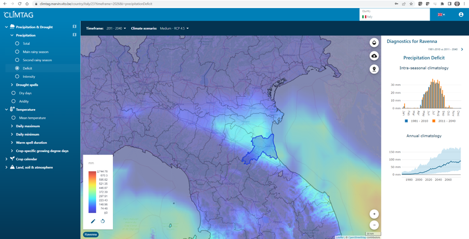
A wealth of climate data exists, among others in the renowned Copernicus Climate Data Store (CDS).
Yet, the data are often difficult to access and interpret. VITO therefore translates this data into operational and interpretable agro-climate indicators. This valuable climate information is accessible via Climtag ™. We use temperature, precipitation and a variety of other climate data from past climate reconstruction (‘ERA5 reanalysis’) and future climate projections up to 2100 (‘CMIP5 projections’), to calculate operational agro-climate indicators that are offered within our Climtag application™. The CMIP5 climate projections are bias-corrected to strengthen their consistency with the past observed climate. Based on orographic information, the indicators are downscaled to a resolution of 1km x 1km to ensure practical applicability in the field.
The offered climate information allows Climtag™ users to assess the severity of upcoming climatic changes and their impact on agricultural production and design robust adaptation measures.
Knowing better how the climate will evolve in specific regions will also allow to select trial locations today in regions that mimic these future climatological conditions. Climate change will not only have impact on abiotic stress, but also biotic stress conditions can be predicted through these modelled agro-climatological variables. It will help to predict which crops and environments become more vulnerable to specific pests and diseases and help breeders taking decisions in this domain.
Last but not least, the next season forecasts that Climtag provides will greatly help you to improve the selection of the right test regions to organize your (drought) trials for the upcoming season.
Conclusion
Agriculture is facing unprecedented challenges due to climate change and the increasing constraints on the usage of plant protection and fertilizers. Developing climate-resilient crops that can adapt to extreme weather conditions is becoming more urgent, and the integration of multiple disciplines and technologies, including genotyping, phenotyping, and envirotyping, can accelerate the breeding process.
Large scale phenotyping data collected through drones and satellite imagery can provide valuable insights into the performance of crops in different environments and offer significant benefits in terms of scalability. These technologies have become increasingly affordable and can be deployed at scale. Additionally, predictive climate models based on climate data can help to steer breeding programs and help in better selection of environments that today mimic the conditions of the target region for your varieties.
VITO, as an independent research organization, provides scientific grade reliable and scalable technology solutions to help seed breeding companies and input suppliers to get more and better data on the table, bringing all these elements together will help to speed up the breeding programs to breed new climate resilient crop varieties.
Contact us to find out more and see if you can speed up your breeding process with large scale phenotyping.